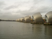
This website is an unnofficial guide to the Thames Path, a National Trail footpath running for 180 miles along the banks of the river Thames. Starting at the Thames Flood Barrier at Woolwich in South East London it runs along the banks of the Thames to Kemble in Gloucestershire. As it follows the banks of the river, the path is flat, making for easy walking and with much of the river being a busy waterway, there is usually plenty of activity to watch.
|
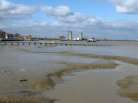
| The Thames Barrier to Greenwich (4.5 miles) |
| The impressive Thames flood barrier marks the start (or end) of the Thames Path National Trail as the river widens to the sea. This walk heads in the other direction, upstream towards central London. The Thames was once a busy working river and heading west from here you'll see that parts of it still are, as the walk goes through an area of industry. It then rounds the Greenwich Peninsula, rounding the O2 entertainment venue and continues through a new residential area to reach the historic centre, a World Heritage site. There is so much to see here it is well worth spending the time exploring. |
|
|
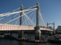
| Greenwich to the London Eye (7.5 miles) |
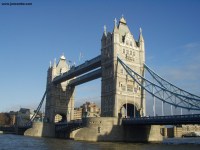
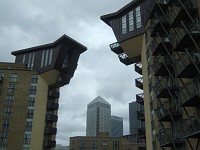
| This walk begins from the Cutty Sark in Greenwich and heads through Deptford, Rotherhithe and Bermondsey, overshadowed by the massive towers at Canary Wharf across the river. Much of the area was
formerly industrial buildings which have now been converted into flats. Soon you head under Tower Bridge, past
City Hall and into the centre of London, with it's many grand buildings, to finish at the London Eye on the South Bank. |
|
|
| Island Gardens to Embankment (7.5 miles) |
| This walk takes in the Thames Path on the north banks of the Thames as it starts at Island Gardens, just accross the river from Greenwich. From Greenwich the path heads west around the Isle of Dogs and then round the modern Docklands area, giving views of the many sky-scrapers that now exist there. Continuing west the path passes Limehouse Basin and the Regents Canal continuing through historic Wapping and St Katherine's Dock under Tower Bridge and into central London, following the embankment west to Embankment Station. |
|
|
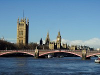
| Barnes Bridge to Embankment (11 miles) |
| This walk follows the Thames east from Barnes Brige in Chiswick passing through Chiswick, Hammersmith, Fulham and Chelsea. Continuing east from Chelsea the walk takes in the sights of central London including the Tate, Houses of Parliament and London Eye, finishing at Embankment. |
|
| | The London Eye to Putney (8 miles) | | This walk from one of London's newest and most famous landmarks, the London Eye. The path continues past County Hall, past modern offices to Vauxhall. The path then heads "inland" past Battersea Power Station then on through Battersea Park. The path continues from the park past modern apartments towards Wandsworth. There is some more "inland" walking round Wandsworth, then into Wandsworth park and into Putney, the end of the walk. | |
|
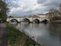
| Barnes Bridge to Teddington (12 miles) |
| This walk follows the Thames west from Barnes bridge, keeping to the north bank of the Thames. The walk takes in the pretty village of Strand-on-the-Green and on through Brentford, Syon Park, Isleworth, St Margarets, Twickenham, Strawberry Hill and Teddington, the tidal limit of the Thames. |
|
|
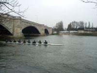
| Putney to Richmond (8 miles) |
| This walk parallels the route of the famous Oxford v Cambridge boat race from Putney to Chiswick, continuing on to Richmond where I stopped (after an abortive attempt to continue onto Teddington). The path passes the Wetlands Centre on the left passing under Hammersmith bridge into Barnes, then on to Kew, passing the famous Royal Botanical Gardens on the left, then the Old Deer Park into Richmond. |
|
|
| Richmond to Hampton Court (8 miles) |
| The interesting town of Richmond is the start point for this walk, where the Thames takes on a m
ore rural feel. From Richmond you pass through Petersham Meadow, past Marble Hill House and Ham House, through
quite rural settings to Teddington Lock, which is the point at which the Thames is no longer tidal. From Tedd
ington you continue into the town of Kingston-upon-Thames then on along the edge of Hampton Court Park to the
historic Hampton Court Palace. |
|
|
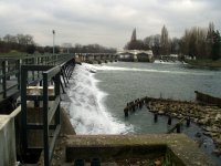
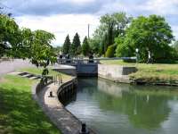
| Hampton Court to Staines (12 miles) |
| The Thames becomes considerably more rural beyond Hampton Court, passing through the last of the London suburbs and out into the towns of Surrey, ending in Staines. The path passes several locks and weirs on this section of the path and even includes a ferry crossing. |
|
|
| Staines to Windsor (8 miles) |
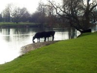
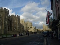
| Starting from the busy town of Staines, this walk heads from the re-developed riverside out to the meadows of Runnymede, where the Magna Carta was signed. The meadows give way to the residential properties lining the Thames at Wraysbury before heading along the edge of Windsor Great Park through the attractive village of Datchet and finally Windsor, with it's magnificent castle. |
|
|
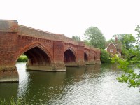
| Windsor to Bourne End (11 miles) |
| This walk heads away from Windsor and it's dominating Castle out to open fields alongside the Thames. After several miles of open countryside the Thames comes into Bray and on into Maidenhead, with it's many large houses. Beyond Maidenhead, cliffs line the North Bank of the river as the Thames Path heads briefly away from the river into the attractive village of Cookham, then continues through meadows into Bourne End. |
|
|
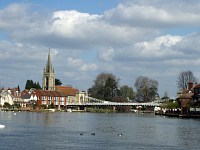
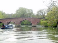
| Bourne End to Henley-on-Thames (11.5 miles) |
| This part of the Thames path heads through open fields from Bourne End to the beautiful town of Marlow. Beyond Marlow, the Thames path passes through the villages of Temple, Hurley and briefly leaves the river at Aston. Returning the river, the Thames path goes past Hambleden Lock, with it's large weir, then round through Remenham to the beautiful town of Henley-on-Thames, home of the famous regatta. |
|
|
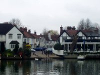
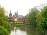
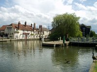
| Henley-on-Thames to Tilehurst (12.5 miles) |
| The Thames path quickly becomes rural from Henley-on-Thames into the lovely village of Shiplake
where the path briefly leaves the river. From Shiplake there is several miles of peaceful walking before arriving at the attractive village of Sonning where the Thames path switches banks on its way to the busy town of Reading, where the Thames joins the Kennet and Avon Canal. Passing through the town the Thames then runs parallel to the Great Western Railway on the approach to Tilehurst, the end of this walk. | |
|
|
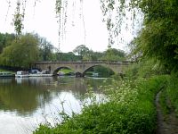
| Tilehurst to Cholsey (11.75 miles) |
| This walk starts with some more urban walking through the residential streets of Tilehurst, returning to the Thames at Mapledurham Lock. The path then continues on the south bank of the river as far as Pangbourne where it then crosses the river into Whitchurch and climbs onto the edge of the Chilterns, briefly away from the Thames. The path returns to the edge of the Thames a mile or two later and continues next to the river to the end of this walk near Cholsey. | |
|
|
| Cholsey to Dorchester (9 miles) |
| This walk goes through rural Oxfordshire and starts in the small town of Cholsey passing open meadows into the attractive market town of Wallingford. From Wallingford it's a short walk past meadows to Benson Weir, where the Thames path crosses the river. The Thames Path once again briefly leaves the river to pass through the lovely village of Shillingford, returning to the Thames just out of the village, and continuing to the edge of Dorchester. | |
|
|
| Dorchester to Abingdon (9 miles) |
| This walk starts in historic town of Dorchester, with it's abbey, rejoining the Thames and continuing over the beautiful Clifton Hampden Bridge to the north bank of the Thames. This part of the path is very rural in character, passing several villages, mostly on the opposite banks of the river, and two navigable cuts to the river at Clifton and Culham before arriving in the busy market town of Abingdon. |
|
|
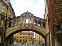
| Abingdon to Oxford (8.5 miles) |
| This walk starts in the market town of Abingdon and after crossing the abbey stream, the river runs through open countryside for several miles, passing close to Radley, to the beautiful village of Sandford-on-Thames. Here the path is on the island by the lock briefly before returning to the bank to pass through picturesque Iffley Lock and on to the stunning city of Oxford, the last major town on the Thames from London to the source. |
|
|
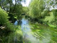
| Oxford to Northmoor (11 miles) |
| The stunning city of Oxford is the start point for this walk, the last city on the path to the source, and one that is well worth taking a look round. From here to the source the path is now very rural, passing through only a couple of small towns. The rural feel starts almost immediatly from Oxford where the path goes through open meadows, past the reamins of Godstow Abbey, after which the Thames becomes noticeably thinner as it twists round the many corners, on the way to Swinford, with it's lovely bridge. This walk continues from Swinford to Northmoor Lock with the village a mile or two inland. |
|
|
| Northmoor to Tadpole Bridge (9 miles) |
| This walk is the first on the Thames path that doesn't pass through any significant towns. Starting from Northmoor, just off the path it pases under Newbridge, in fact one of the oldest bridges on the Thames, dating from the 13th Century. Beyond Northmoor the path pases under a couple of footbridges and follows Shifford Lock Cut then on to Tadpole Bridge. |
|
|
| Tadpole Bridge to Lechlade (10.5 miles) |
| Starting from the rural Tadpole Bridge the Thames is now narrowing as it twists its way through the open countryside of Oxfordshire, passing the villages of Kelmscot and Radcot on the way to the market town of Lechlade-on-Thames. |
|
|
| Cricklade to Lechlade (11 miles) |
| This walk links the two Cotswold towns of Cricklade to Lechlade-on-Thames and follows the Thames in the opposite direction to the other walks. The Thames is not navigable after a few miles west of Lechlade and so this is the first walk where the path does not follow the banks of the river for much of the time. Despite this it's a pleasant walk through unspoilt countryside to the pretty village of Castle Eaton and on to Lechlade-on-Thames. |
|
|
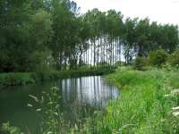
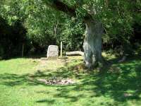
| Cricklade to The Source (12 miles) |
| The final part of the Thames Path is from the town of Cricklade, to the source of the Thames, near Cirencester. Soon after leaving Cricklade, the path pases into the Cotswold Water Park round the edge of several lakes, the largest being Manorbrook Lake before coming into the lovely town of Ashton Keynes. Beyond Ashton Keynes the Thames again pases more lakes and the edge of the villages of Somerford Keynes, Ewen and Kemble on it's way to the stone that marks the source of the Thames and the end of the Thames Path. |
|
The Thames Path extension is an extension to the National Trail and follows the banks of the Thames further east from the Thames Flood Barrier.
Whilst this web site covers the Thames footpath it is also pleasant to travel along the Thames by boat, particularly if you have young children, for example. The good news is it is possible to travel along most of the Thames by boat, be it a public boat or a hired boat. The following pages detail public boat services along the Thames as well as information on hiring a boat for use on the Thames.
Every effort is made to ensure the accuracy of information on this site, but liability will not be assumed in the event of any inaccuracies. Use of the information on this site is at your own risk. If you find any errors, please use the link below. The text and photographs on this web site are all Copyright © and may not be reproduced without prior permission.